
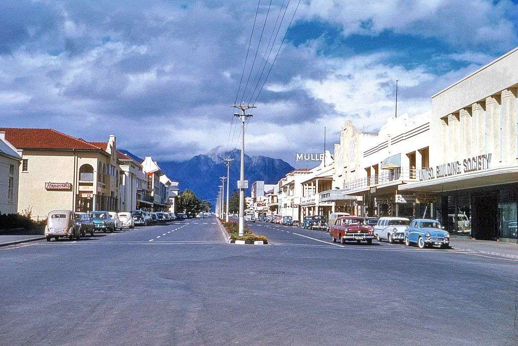
- Province: Western Cape
- District: Cape Winelands
- Coordinates: 33°38′42″S 19°26′37″E
- Area: 73.2 km2
- Municipality: Breede Valley
Worcester is a town in the Breede River Valley of the Western Cape, about 120 km northeast of Cape Town. It lies along the N1 highway and serves as the main commercial and administrative centre of the Breede Valley Municipality. The surrounding area is known for vineyards, fruit orchards, and mountain scenery, making Worcester a hub for agriculture and tourism.
History of Worcester
Wildlife and Elephant Tusks
Before 1700, the area around the Breede River was abundant with wildlife. The Dutch East India Company (VOC) granted licenses for hunting, including the trade of elephant tusks. The indigenous Khoi people traded livestock with European settlers, but a smallpox epidemic in 1713, brought by the Europeans, nearly wiped out the Khoi population.
Establishment of the town
The town was established in 1818 by Lord Charles Somerset, following a suggestion to create a new municipality between Tulbagh and Graaff-Reinet. On 9 January 1819, the Colonial surveyors, Tulleken and Hertzog, mapped the two farms, and on 4 November, the first official advertisement for the sale of plots was issued. Worcester was established as a sub-magistracy, as Tulbagh was somewhat remote for the growing number of farmers in the area.
The town was founded on the farm Hooivlakte and named after the eldest son of Lord Charles Somerset’s brother, the Marquis of Worcester. It first appeared in the government gazette in 1819, announcing the sale of plots. By 28 February 1820, 89 of the proclaimed 144 plots were sold. Worcester was declared a separate district in 1822 and was only granted municipal status in 1842. After devastating floods destroyed the magisterial building in Tulbagh, it was decided that the seat of the magistracy was moved to Worcester.
German Settlers and Viticulture
The sale of town plots was delayed due to civil unrest on the Eastern border, but on February 28, 1820, the Union Jack was raised to signal the start of sales. German settlers, skilled in agriculture, improved the land and cultivated fruit. However, after World War II, the declining demand for dried fruit led farmers to shift their focus to viticulture. When the town was being laid out, the magistrate of Tulbagh ordered the collection of oak trees, and 48 were planted along the streets of Worcester, many of which still stand today.
The local microclimate and fertile soil make the area one of South Africa’s most important grape-producing areas, with over 17 million cartons of table grapes exported each year. The first export grapes were planted in the Hex River Valley around 1875. The completion of the Greater Brandvlei Dam in 1936, later expanded in 1987, further fueled agricultural productivity by supplying reliable water to local irrigation systems.
The first electrical generators, powered by a pipeline from the Fonteintjies Mountain, were installed in 1916. The arrival of the railway in 1873, connecting the town to Cape Town, boosted trade and travel. It became a popular stopover for travellers going to the diamond mines in Kimberley. People like Barney Barnato and Cecil John Rhodes often stayed over in Worcester on their travels. Find out more about railways in the Western Cape
Gables
Worcester has a notable collection of historic buildings, with Georgian, Victorian, Art Deco and Cape Dutch architecture represented in the town. Its historic streets are particularly known for their elaborate gables. During the 19th century, prominent families built increasingly decorative homes, creating a concentration of distinctive gabled buildings along streets such as Baring and Adderley Streets. This local competition for impressive façades has sometimes been described as the “Worcester Gable War.”
Worcester is known for its schools for the blind and deaf, which were established by the Dutch Reformed Church in1881. The church also runs a printing press producing braille publications in several languages.
Returning War Veterans
. After World War I, Black African veterans returned to Worcester, where they were employed as cheap labour for construction projects. Due to a housing shortage, a squatter camp developed at Parkersdam.
Zwelethemba Township
Zwelethemba was established as a direct result of South Africa’s Slums Clearance Act of 1934, which allowed municipalities to demolish areas classified as slums. Worcester’s earlier settlement, known as Sakkiesdorp, was de-proclaimed in 1950 due to overcrowding.
Residents were forcibly moved approximately 5 km away from the town, in a process similar to removals from District Six. This relocation led to the development of Zwelethemba.
The name Zwelethemba comes from isiXhosa and means “Nation of Hope.” The area was initially known as eMtshokotshweni, referring to the concrete slabs used in early housing construction. As the settlement grew, it became known as Khwezi, meaning “Morning Star,” before finally adopting the name Zwelethemba.
Interesting facts:
- The first time a springbok was used as an official sporting emblem was in Worcester. In 1882, the local Worcester Rugby Club became the first club in the country to embroider the jumping antelope onto their jerseys, many years before the national rugby team officially adopted the name and logo during their 1906 tour of the UK.
- For many years Worcester was home to Cape Glove, a world-renowned factory that produced exceptionally fine leather gloves. Their craftsmanship was so legendary that they secured the exclusive contracts to manufacture gloves for global luxury fashion houses, international military officers, and even European royalty.
The license plate prefix is CW, and the postal codes are 6850 (streets) and 6849 (boxes)
Transport
Worcester is served by Metrorail Golden Arrow Bus Services, and minibus taxis. See linked pages for details. Other options for getting around the Western Cape.
weather in Worcester today
Browse busineses and places to visit in Worcester
Things to see and do in Worcester
- The Afrikaaner museum is in an attractive old cottage with a collection dating back to the mid-nineteenth century. There is a display showing surgeries that were performed at that time, and a display of dental and surgical equipment that was used. used. The cottage was originally a residential home. 75 Church Street-023 342-2225
- Kleinplaasie showgrounds
- Pioneer School Heaven & Hills MTB – raises funds for the Visually Impaired and Blind 023 342 6244
- This town is known for its schools for the blind and “Blind friendly” streets.
- Blindianna museum
- This is the only town in SA that has traffic lights that emit sounds to signal colour changes to enable blind people to cross safely
- Karoo National Botanical Garden
- Gliding club at the Worcester Airfield 082 803 1797
- Brandvlei Dam derives its name from the country’s strongest mineral spring.
- Nuy Valley Fest
- The Rainbow 30km race is held annually; it is an out-and-back course from the Institute for the Deaf Sports Grounds. 082-771-1543
- Garden of Remembrance, designed in 1919 by Hugo Naude, to commemorate the founding of Worcester
- The Beesloop is held during March. It includes a road race between vineyards and orchards, a fun walk, a fun fair, tractor rides, and more at The Farm Oudewagendrift 082-3318889 Evd20@hotmail.com
- The KWV Brandy Cellar in the town is globally recognized as the largest copper potstill brandy distillery in the world operating under a single roof. It houses 120 historic copper potstills,.
- Karoo National Botanical Garden: This is the only desert garden of its kind in the Southern Hemisphere with a dedicated Braille Trail. The path was meticulously designed with specific textured, aromatic, and mathematically unique desert succulents, allowing visually impaired visitors to experience the flora entirely through touch and scent
- Dutch Reformed Church, Built in 1832
- Browse wine farms in the Worcester district
- Old Town Walking Route to discover the rich history of Worcester’s old town
- For a guided tour, enquire at the tourism office
- See also Rawsonville
Resources
For permits, fishing rules, regulations and other practical outdoor information relevant to Worcester, see the Colourdots coastal and nature use guide

Useful Numbers in Worcester
Residents and visitors can find important local contact numbers below, including police, medical services, utilities, and community facilities in and around
-
Emergency Services
- Police: 023 316 1854
- Fire: 023 348 9060
- Ambulance: 10177
- Medical
- Closest hospital: Provincial Hospital -023 348 1100
- Pharmacy; 023 347 0844 (Quenet’s Family)
- Municipal & Utilities
- Water: 0860 12 12 12
- Electricity: 0860 12 12 12
- Transport & Roads
- Road Emergencies / SANRAL: 0800 204 204
- Traffic department: 023 347 0959
- Community & Safety
- Poison Information Centre: 0861 555 777
- Snake/Scorpion/Spider Bite Hotline: 021 931 6129
- Childline South Africa: 116
- SPCA: Animal welfare 023 347 1049
- Local Contacts and Community Resources
- Home Affairs: 023 348 8300
- Post office; 023 342 6460
- Library: 023 348 277
- Museum; 023 342 2225
- Tourism; 023 348 2795
- Schools in Worcester
- Worcester Primary School-023 347 0663
- Worcester Gymnasium-023 347 0426
- Lanner House School | An independentschool-023 347 5837
- Drostdy Technical High School-023 342 2320
- Worcester Secondary School-023 342 0857
- Victoria Park Primary School, Worcester-023 342 0770
- Worcester-Noord Primêre Skool sports grounds-023 347 0325
- Hexpark Primary School-023 347 5537
- P.J.B. Cona Primary School-023 345 1434
- Riverview Primary School-023 347 1817
- Laerskool Worcester-Oos-023 347 0453
- Somerset High School-023 346 4031
- Worcester NGK Oefen Primary School – 0233423993
- Vusisizwe Secondary School-023 345 2426
- Hoërskool Montana 023 347 0476
- Esselen Park Senior Sec School-023 347 0174
- Worcester RK Primary School – 0233423133
- Scherpenheuwel NGK Primary School 0233404149
Where is Worcester located?
It is in the Breede River Valley of the Western Cape, about 120 km northeast of Cape Town along the N1 highway.
What is Worcester known for?
It is known for its vineyards, fruit orchards, agriculture, and historic buildings.
What facilities are available in Worcester?
The town offers schools, healthcare facilities, shops, administrative offices, and tourism services.
- Colourdots is an independent regional information resource for the Western Cape.
Learn more about the project HERE