History of Athlone
- Province: Western Cape
- Coordinates 34°0′S 18°30′E
- Area 2,445 km2
- Municipality City of Cape Town
Athlone got its name from Alexander Cambridge, 1st Earl of Athlone, the Governor-General of and Commander-in-Chief in South Africa. He was a member of the royal family and was in this position from 1924 to 1930. Previously, the area was called West London.
Geologically, the Area is a vast sheet of Aeolian sand, originally of marine origin. It would have been blown up from the adjacent beaches over about a hundred thousand years. Below the sand, the bedrock consists of Malmesbury Shale. Most of the sand is unconsolidated, but in some places near the coast, the oldest dunes have been cemented into a soft sandstone. These formations contain fossils of animals such as the extinct Cape lion and also show evidence of Stone Age people hunting in the area tens of thousands of years ago.
The area has been called the dumping ground of the apartheid regime, where thousands of people were relocated because of the Group Areas Act. 70 years after the Earl of Athlone left, it became a melting pot and it is an example of how many different cultures can coexist.
The train station is on the Cape Flats line. Other parts of the district include Manenberg, Gatesville, Rylands, Belgravia Estate, Bridgetown, and Hazendal. Garlandale, Rondebosch East, Crawford, Silvertown and Kewtown, but also Bokmakerrie, which is an older area that was built before World War II
Athlone is the cultural hub of the Cape Flats community
WEATHER IN ATHLONE TODAY
see all listings in Athlone
Things to see and do in Athlone:
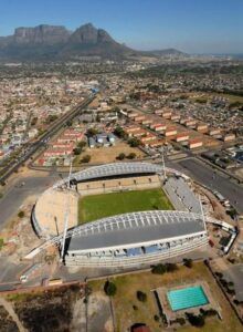
- Athlone stadium
- Athlone Power Station, or the ‘Cooling Towers’, was built in 1960 and is managed by the Cape Town City Council. Today, it is declared out of bounds due to damage caused to the structure by the strong Southeastern wind.
- The Robert Waterwitch / Colleen Williams Memorial was established in memory of two activists who died in the anti-apartheid struggle
- Power station cooling towers are the remnants of the expired power station.
- Nantes Park Outdoor Gym, Loerie Road, Silvertown

- The Gatsby mural in Kannabast commemorates the creation of this Cape Town speciality.
-
The Trojan Horse Memorial in Thornton Road commemorates a tragic event that happened during a peaceful anti apartheid protest.

Useful Numbers
-
-
- Police: 021 697 9200
- Traffic department: Hillstar 0860 103 089
- Fire: Goodwood 021 590 1900
- Water: 0860 103 089
- Electricity: 0860 103 089
- Ambulance: 10177
- Post office; 021 697 1201
- Closest hospital; Dr. Abduraham Day hospital 021 37 9071
- Pharmacy; 021 697 1613
- SPCA: Cape of Good Hope 021 700 4140
- Athlone civic centre 021 637 5488
- Community centre 021 444 0410
- Schools:
St Raphaels primary – 021 696 6718
Garlandale secondary – 021 696 7908
Alicedale Primary – 021 637 6730
Athlone North Primary – 021 637 6608
Ned Doman high – 021 696 5114
Garlandale Primary – 081 448 6799
Athlone High – 021 637 6930 - Find a comprehensive list of Cape Town emergency numbers
- The City of Cape Town Public Emergency Communication Centre is available 24/7 For all life or property-threatening emergencies, call 021 480 7700 from any phone or 107 from a landline or report online at https://bit.ly/3o4Ji3K
-
Other Cape Flats towns and suburbs include: Atlantis; Belhar; Blue Downs Bonteheuwel; Crawford; Eerste Rivier; Epping; Grassy park; Hanover Park; Khayalitsha; Kuils River; Langa; Lansdowne; Lotus river; Macassar; Mannenberg; Mitchells Plain; Nyanga; Ottery;and Philippi


