Camps Bay

History of Camp’s Bay

  • Province Western Cape
  • Coordinates; 33.9513° S, 18.3831° E
  • Area 1.68 km2
  • Municipality City Of Cape Town
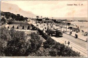
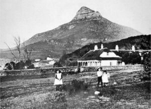
  • ……………………………………………………………………………..

Camps Bay, originally home to the Goringqhaique Khoi and nomadic San people, was a forested region with rich wildlife. As the Dutch established their presence in the Cape, these indigenous communities were gradually displaced. By 1657, the Goringqhaique had moved to Camps Bay, which would later become historically linked to Zwarte Maria Evert, the first known owner of the land.

Maria, born in 1663, was the daughter of enslaved parents taken from Benin. Her father was the first male slave freed in the Cape, and he eventually gained freedom for both Maria and her mother. He had been granted a plot of land, where he lived and ran a garden. Maria sold the produce from the garden for her father. she learnt how to make deals and how one could acquire land, she became the owner of several Farms in the Cape.

Through her business dealings and land acquisitions, Maria became wealthy. In 1713, she was granted a title deed for land that included what is now Camps Bay.

However, in the same year, a smallpox outbreak from a Danish ship led to a deadly epidemic. Soiled linen was sent ashore to washerwomen in Cape Town. This initiated the epidemic that spread throughout the entire colony.  It claimed Maria’s life and her son’s. However, she left behind a considerable estate, as one of the wealthiest people in the colony.

By 1713, the Goringqhaique settlement was confined to Oudekraal. The area was then granted to John Lodewyk Wernich, who passed it on to his son Johan. Johan married Anna Koekemoer, and after he died in 1778, Anna married Fredrick Ernst von Kamptz,a Dutch sailor. As a result, the area became known as Die Baai von Kamptz.

. For about 100 years, Camps Bay remained largely undeveloped and was primarily used for hunting. The construction of Victoria Road in the late 1800s and the introduction of a tramway in 1901 boosted accessibility and spurred further development, transforming Camps Bay into a recreational hotspot.


Vintage pictures from Saartjie Klipkop                         First house in Camps Bay

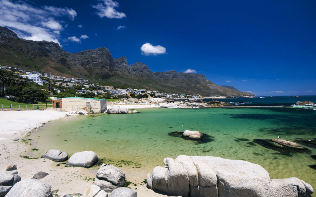
Today, the suburb is an upmarket and popular area, known for its beach, which has Blue Flag status. The bay’s geography, protected from the South-Easterly winds, makes it relatively windless. Glen Beach, adjacent to Camps Bay Beach and divided by a rocky outcrop that becomes a single stretch of sand in summer, is popular with surfers but not suitable for swimming. It is usually less crowded than the main beach

Postcodes in Camps Bay are 8005 (Streets) and 8040 (Boxes)

Things to see and do in Camps Bay

  • The Round House
  • Little Glen playground is a playground in the Little Glen Nature Area. There is a jungle gym & tree swings
  • Signal hill road
  • Kloof Nek Road, one of South Africa’s oldest roads, was built in 1848 Ingleside Road Park has amazing views! the play area has great views of the Atlantic Ocean and The Twelve Apostles.

WEATHER IN CAMPS BAY TODAY

All listings in Camps Bay

Useful Numbers

  • Police: 021 437 8150
  • Traffic department: Gallows Hill: 021 444 3811
  • Fire: Sea point 021 434 2020
  • Water: Department of Water and Sanitation 021 546 3452/0860 103 089
  • Electricity: 0860 103 089
  • Ambulance: 10177
  • Post office; 021 438 9640
  • Library; 021 444 0487
  • Closest hospital/clinic;  Somerset Hospital Green Point 021 402 6911
  • Pharmacy; 021 438 2088
  • SPCA: Cape of Good Hope ( Grassy Park) 021 700 4140
  • Schools: Camps Bay High: 021 438 1507
    Camps Bay Primary: 021 438 1503
    Camps Bay Preparatory: 021 438 8075
  • Ratepayers Association: 083 628 9105/021 438 8287

Local Listings

Sear