Jump to:
Plan Your Visit • opening times and entrance fees – How to get to Cape Point.
Discover the History • Cape Point history and geology – First people and archaeology – Early settlers and the lime industry – Shipwrecks and perilous waters – The lighthouses of Cape Point – Legends and interesting facts.
Explore Cape Point Wildlife and nature at Cape Point – Beaches at Cape Point – Fishing at Cape Point – Things to see and do at Cape Point – Regulations and permits
Overview
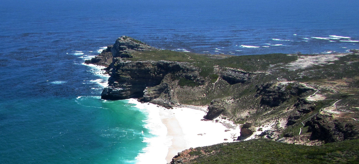
Cape Point is located at the southern end of the Cape Peninsula in Table Mountain National Park, about 70 km south of Cape Town’s city centre. The reserve is reached via the M4 coastal route through Simon’s Town and Scarborough, with the main entrance gate at Cape of Good Hope. The area of 7750 hectares includes high sea cliffs, walking routes, beaches and the historic Cape Point lighthouses, and is managed as part of the national park system with controlled access, entrance fees and set daily opening hours. The weather can be windy in summer and rough in winter, so be prepared and check before setting out.
Plan Your Visit
Opening Times and Entrance Fees
Opening times vary according to the season, typically following daylight hours.
- October to March 6.00 am to 6.00 pm
- April to September 7.00 am to 5.00 pm
Rates can be found here. There are special rates for locals (identity document required). For some activities, a pensioner’s rate also applies.
Check WindGuru for wind speed and direction
How to Get to Cape Point
MAP The Cape Point Nature Reserve is just a 1-hour 20-minute drive from downtown. It is about 68 km. There are two options: self-drive or join an organised tour,
Via Chapman’s Peak
Take Victoria Road towards Camps Bay. Continue to the roundabout, take the 3rd exit onto Main Road towards Chapmans Peak, this is a toll road. Head southwest to follow the M6, turn right towards Ou Kaapse Weg. Keep following the M6, continue till Main road, Simon’s Town, turn right, continue to Cape of Good Hope Drive to your destination
Via M3 M75 and M4
Take N2 towards Somerset West and Muizenberg. Continue on the M3 towards Muizenberg, keeping right, take exit 23 or M42 Steenberg Road, turn right onto Main Road, continue, take a left onto Boyes Drive or continue on Main Road. If you take Boyes Drive when you again reach Main Road, turn right. Continue on Main Road, turn right into Redhill Road, then merge into Plateau Road M65, follow Cape of Good Hope Drive to your destination
Discover the History
Cape Point History and Geology
Cape Point is a rugged promontory formed in the ice age of 2.6 million years ago, when glaciers covered most of the Earth’s surface. During the interglacial periods, water levels increased, and sediment was deposited on the shore. The Cape Peninsula is made up of three main rock types that formed hundreds of millions of years ago and helped shape the landscape seen today.
The southeastern corner of the Cape Peninsula is one of South Africa’s most breathtaking natural landmarks. It forms part of the Cape of Good Hope section of Table Mountain National Park, and it is the windiest place in South Africa. Read more about the Cape Peninsula in Geology of the Western Cape
First People and archaeology
Cape Point was home to some of the earliest people to live on the southern tip of Africa. Archaeologists have found evidence of human activity in caves and rock shelters dating back hundreds of thousands of years. Sites such as the Bonteberg Shelter and the cliffs above Black Rocks have revealed stone tools, pottery fragments and enormous shell middens left behind by early coastal communities. These shell heaps, built up over thousands of years by generations of beachcombers, later became one of Cape Point’s most valuable resources.
Early Settlers and the lime industry
By the 1800s, the Cape Point area had been divided into farms such as Buffelsfontein, Olifantsbosch and Klaasjagers. Farming conditions were harsh, with poor sandy soil and fynbos that cattle struggled to graze on. Instead, settlers turned to lime production. Seashells and calcrete rock were burned for days in kilns to produce lime, which was used in mortar and whitewash for buildings in Cape Town and Simon’s Town. Buffelsfontein became the centre of this industry. Under owners such as John McKellar, who also introduced ostriches to the area, large quantities of lime were produced from shells gathered along the coast. Later, the land became part of the Cape Point Lime and Cement Works before eventually being incorporated into what is now the protected Cape Point section of the Table Mountain National Park.
Shipwrecks and Perilous Waters
However, many sailors found it to be a perilous and treacherous stretch due to powerful winds, strong swells, and unpredictable currents. Since records have been kept, 26 ships have met their end on the coast of Cape Point. Two primary hazards have claimed many of the vessels:
Bellows Rock – Visible as either a dark patch or whitewater about 3 km south of Cape Maclear, and Albatross Rock – Located 1 km west of Olifantsbosch Point.
The Olifantsbos Trail leads through fynbos to the beach, where the Thomas T. Tucker ran aground in 1942. This American WWII transport vessel’s hull is a popular nest for local birdlife. Also, the remains of a pirate ship, Le Napoleon (wrecked in 1805) are often visible near the Olifantsbos Point carpark. ,
Find a list of some of the ships that have wrecked off Cape Point
The waters are also particularly dangerous because of the Roaring Forties, fierce westerly winds that circle the globe at 40° latitude. Large tracts of open water along these latitudes allow high wind speeds to develop.
The Lighthouses of Cape Point
Old Lighthouse (262 m above sea level) – Built in 1859, it proved ineffective due to frequent fog. This is cited as the reason the Portuguese liner Lusitania sank on April 18, 1911, when it struck Bellows Rock. This tragedy prompted the relocation of the lighthouse to a lower elevation for better visibility in misty conditions. The New Lighthouse was built at 87 m above sea level. Click the link for more information.
Legends and interesting facts
Despite popular belief, this is not where the Atlantic and Indian Oceans meet. This fluctuating boundary usually occurs between Cape Agulhas and Cape Point. The merging currents, however, influence Cape Town’s microclimate.
When Sir Francis Drake rounded Cape Point in 1580, he famously described it as “a most stately thing and the fairest Cape in the whole circumference of the Earth.” It must have been one of the good days. On a clear day, you feel as if you could see Antarctica, but that is at least 6,000 kilometres away.
There is an enduring legend of the Siren of Cape Point, described as a ghostly figure who appears on the rocks, luring ships to their doom.
Sailors’ tales over the centuries describe the siren as a beautiful woman with long, dark hair. She is said to be seen sitting near the water’s edge, singing softly or just sitting in silence. Her presence captivated sailors from passing vessels. She would vanish into the waves when anyone approached.
. The legend of the siren may have explained some of the tragedies at Cape Point; however, no evidence has ever been found
Explore Cape Point
Wildlife and nature at Cape Point
Cape Point remains largely undeveloped, providing a vital haven for seabirds and endemic vegetation. The region is home to Peninsula Sandstone Fynbos, a collection of plant species endemic only to the Western Cape.
The area is home to many species of birds. Over 270 species have been recorded in the area, from tiny sunbirds to ostriches. The local plant life supports canaries, shrikes and warblers. Also, naturally, there are seabirds. See this comprehensive Western Cape bird guide.
See an illustrated Western Cape Wildlife Guide, animals you may see
Illustrated guide to local snakes and what to do if you get bitten.
Cape Point is a top tourist destination, offering a variety of outdoor activities:
Beaches at Cape Point
Platboom and Olifantsbos – Diaz Beach – Maclear Beach – Miller’s Point – Smitswinkel Bay – Buffels Bay and Tidal Pool
Illustrated guide to Western Cape Seashells Identification
Fishing at Cape Point
Cape Point is a well-known spearfishing area with productive reefs and a variety of fish species, but conditions can be difficult and unpredictable. Strong currents, changing weather, and large swells are common, and divers should avoid seal colonies, which can attract large sharks. The area is better suited to experienced spearfishers who are familiar with local sea conditions and safety precautions
Rooikrans, near Cape Point, is regarded as one of South Africa’s best shore fishing spots. Anglers target species such as galjoen, blacktail, hottentot, yellowtail, and kob from the rocky cliff ledges. Conditions can be dangerous, especially during large swells, and the cliffs make landing fish difficult, so the area is better suited to experienced fishermen.
Cape Point and the Atlantic Seaboard are also well known for offshore yellowfin tuna fishing. These powerful game fish are usually targeted between November and June, when the warmer Agulhas Current moves closer to the coast. Tuna are generally found far offshore, and fishing for them requires strength, endurance, and specialised tackle, whether trolling or using live bait.
See the illustrated guide to ocean fish in the Western Cape
Browse businesses and places to visit at CAPE POINT

Things to see and do at
Cape Point
- Dias Cross The Portuguese erected two crosses at Cape Point as a navigational aid– when lined up, they indicate Whittle Rock, a major shipping hazard in the Bay. Two other beacons in Simon’s Town provide the intersection point.
- The Origins of Early Southern Homo sapiens Behaviour exhibition explores early innovations created by our own species in Southern Africa. It presents archaeological discoveries of early material culture and reconstructs how our ancestors lived in close relationship with nature, including the Great African Seaforest, around 100,000 years ago.- Buffelsfontein Visitors Centre,
- World War II Radar Listening Stations: Remnants of a radar station erected in 1942 that projected a narrow radar beam to detect any German U-boats in the vicinity. Other military structures, including the canon on Kanonkop that used to warn Simon’s Town of approaching vessels, can still be seen today.
- The restored kiln used by the “Cape Point Lime and Cement Works”. can be seen in the Reserve where the farm Buffelsfontein was. The farm was bought by George Smith, who started Cape Point Lime and Cement Works. He owned the farm until it was declared a part of the greater Table Mountain National Park in 1939. View the limestone kilns at Buffels Bay and Booi se Skerm.
- Baboons: Please keep your distance and do not feed the Chacma Baboons at Cape Point.
- Ostriches. The ostriches at Cape Point are the direct descendants of the ostriches that JohnMcKellar reared on the farm Buffelsfontein 150 years ago!
- Cape Point Ostrich Farm: Meet South Africa’s biggest birds on a breeding farm situated opposite the entrance to Cape of Good Hope. 021 780 9294
- Hiking & Nature Walks – Explore scenic trails and dramatic cliffs. Mountain biking, diving and surfing are also popular leisure activities within the park.
- Fishing: Permits are required for angling off Rooikrantz in the Cape of Good Hope or game fishing off the coastline. Marine fishing licenses can also be applied for and purchased from any Post Office in the province. See our resources guide above.
- Wildlife Viewing – Spot Eland, Red Hartebeest, Bontebok, and Zebra.
- Birdwatching. With over 270 recorded bird species, including ostriches and sunbirds, Cape Point is a paradise for birdwatchers
- Beaches – Pristine and unspoiled; however, there are areas where swimming is not allowed due to strong rip currents.
- Ride the Flying Dutchman Funicular rail.
- Visit the lighthouses.
- Take the VoiceMap, audio tour
- The information centre is where the original Buffelsvlei Farmhouse stood. Some of the original rafters were made from the wreck of a ship that the owner, John Osmond, had salvaged.
- Shops: Visit the Logo Shop, Cape Point Parks Shop or the Lighthouse 5 shop
- Clean Air Cape Point hosts one of the world’s cleanest air monitoring stations, part of the Global Atmosphere Watch (GAW) network. Researchers use it to study climate change and air quality.
Free guided walks take place on select Sunday mornings, while some activities require permits. Visitors should be aware of safety regulations, including restrictions on swimming
Regulations and permits
Practical information for the Western Cape: regulations, permits, and helpful tips. See the Colourdots coastal and nature use guide
How to be Baboon-wise. Advice on what to do if a baboon joins your picnic
Explore the Western Cape with our comprehensive lists with practical details
Colourdots is an independent regional information resource for the Western Cape.
Learn more about the project HERE