History of Killarney Gardens
- Province Western Cape
- Coordinates 33.8281° S, 18.5366° E
- Municipality City of Cape Town
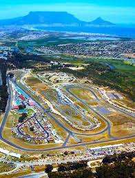
This suburb is an industrial area surrounded by residential areas. It was established in the late 1980s to support the growing demand for industrial and commercial spaces in the city. Initially developed to provide affordable and well-structured facilities for small to medium-sized enterprises, it has since become a bustling hub for various businesses, including manufacturing, logistics, and distribution. The area’s strategic location near major transport routes, such as the N7 highway and the port of Cape Town, has contributed to its economic growth. Today, Killarney Gardens is known for its diverse range of industries, offering a mix of warehousing, light industrial operations, and commercial activities, making it an essential contributor to Cape Town’s economy. Killarney Racetrack is situated close by.
The postcode is 7441
WEATHER IN KILLARNEY GARDENS TODAY
see all listings in killarney gardens
Useful Numbers
- Police: Milnerton Police Station-021 528 3800
- Traffic department: Milnerton -0860 103 089
- Fire: 021 400 6949
- Water:0860 103 089
- Electricity:0860 103 089
- Ambulance: 10177
- Post office; Dunoon 021 556 3561
- Closest hospital; 021 529 9000 Milnerton Mediclinic
- Dunoon clinic -021 200 4500
- SPCA: Cape of Good Hope 021 700 4140


