The Slangkop lighthouse
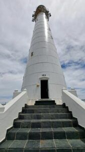
The Slangkop Lighthouse was commissioned in 1906 by the Governor of the Cape of Good Hope, His Excellency, the Honorable Sir Francis Hely-Hutchinson. It was scheduled to be completed in 1914. However, World War 1 broke out and the completion of the lighthouse was pushed back. It was only completed in 1919. It is the tallest cast-iron tower in South Africa standing at 41 meters. The circumference is 33 meters. As the lighthouse is right on the shoreline (only 9 meters above sea level) the height was necessary.
The lighthouse was built using 272 cast-iron segments each weighing 500 kg. These were brought from England and bolted together on site. There are 139 steps arranged in an internal spiral staircase leading up to the lantern level. The stairs are separated by 5 landings.
The mechanical clockwork mechanism that once turned the lens hasn’t been used since 1936. The original oil burners were then replaced with a 4-kilowatt electric lamp. The lighting apparatus was replaced again in 1974. In 1979 the mechanism became fully automated with a light of 5,000,000 candelas that flashes four times every 30 seconds. It can be seen for 30 nautical miles. There is a standby diesel alternator that takes over in the event of a power cut.
There are many reefs and headlands on this coastline that stretch far out into the ocean. This has resulted in many fine vessels being wrecked here. Some of the more famous vessels include the SS Kakapo, which ran ashore in 1900 during a north-west gale. The SS Clan Munroe wrecked to the north of the lighthouse in 1905. The Oakburn wrecked on Duiker Point in 1906 and the SS Maori wrecked in thick fog in 1909. Three graves, believed to be those of sailors from the SS Maori, are close to the lighthouse.

Slangkop Point is one of the few lighthouses in South Africa that is open to the public, and tours are conducted by the keeper. There is also a gift shop and conference centre that can be used for special events.
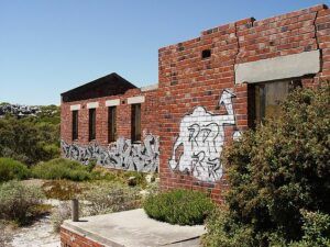
Situated close by are old fortifications, called Kobrakamp. Also, the abandoned radar station built in the 1940s. This was one of many radar stations built during the 2nd world War placed strategically in elevated positions.

GPS S34.148646 E18.319274 34°08’55.1″S 18°19’09.4″E


