History of Nelspoort
- Province: Western Cape
- Karoo
- Coordinates:32°7′S 23°0′E
- Area:72.04 km2
- Municipality: Beaufort West
During the 1700s, Trekboers arrived in the Karoo. These were semi-nomadic farmers. They were Afrikaans-speaking migrants. Previously the land was inhabited by San peoples for thousands of years. Evidence of this comes from rock paintings of an animal, long-extinct and identified as Megalotragus of the bovine genus. This dates the paintings to 10,000 years and older.
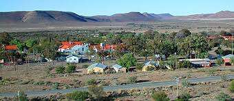
The town of was established when John Molteno, who later became Prime Minister of the Cape colony, established a farming enterprise by that name. He built a large network of farming estates. The enterprise was geared towards the export of the wool. The area continued as a sheep farming area with the farm Nelpoort at the centre.
In the early 20th century, Nelspoort became known for its sanatorium, established to treat tuberculosis (TB) patients. The dry, warm climate of the Karoo was considered ideal for patients with respiratory conditions. The Nelspoort Sanatorium attracted people from across South Africa seeking treatment and contributed to the town’s growth during that period.
local WEATHER TODAY
ALL LISTINGS IN NELSPOORT

Useful Numbers
: Most services are in Beaufort West
- Police: 023 416 1888
- Municipality– 023-4148100
- Traffic Department – 023-4143409
- Fire: 023-4148176 10177
- Water:023 414 8100
- Electricity: 023 414 8100
Ambulance:10177
Post office;
Library:
Closest hospital; 023-4148200
Pharmacy; Nuweveld Pharmacy: 023-4142151
SPCA:
Schools: Restvale Met Primary School- 023 416 1648