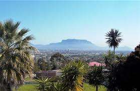
Panorama and Plattekloof is a quiet suburb with a beautiful picnic park and a fabulous historical wine estate. This area, known for its charm, is a favorite among residents and visitors who appreciate the beauty of Panorama and Plattekloof.
Exploring Panorama and Plattekloof
- Province: Western Cape
- Coordinates: 33°52′48″S 18°34′34″E
- Area: 0.91 km2
- Municipality; City of Cape Town
Town planning mix-up
The area that is now called Panorama was awarded to a Mr Booysen and was later transferred to Mr C Meyboom, who called the area De Grendel. The land changed hands several times until it was bought by Sir David Graaff, who farmed dairy cattle. On his death in 1931, the farm passed to his son De Villiers (story), who farmed it under the company name “ Graaff’s Trust”. Part of the farm was sold for residential development in 1956.
The area on a hill is called Panorama (View), and the flatter piece is a Plattekloof (Flat Valley). Unfortunately, the town planners erred and confused the two, so the area on the hillside is named Plattekloof, and the area on the flat valley is called Panorama. The remainder of the farm, De Grendel, is planted with grapevines. De Villiers died in 1999, and his son David took over.
The suburb of Welgelegen includes the following sub-places: Kleinbosch, Welgelegen1,
Welgelegen2, Welgelegen3.
The postcode for these areas is 7500
Things to do and see in Plattekloof, Panorama and Welgelegen
- The Plattekloof Duck Pond park
- De Grendel Wine Estate: De Grendel means “latch” in Dutch. It was established in 1720. Its rich history spans horse breeding to winemaking. The Graaff family has played a significant role in its evolution. The farm was historically the gateway on the route to the inland settlements of Durbanville and Stellenbosch, which had to be opened to travel over the Tygerberg hills
- Tygerberg Nature Reserve
- Malmesbury Road Park Outdoor Gym
Browse businesses and places to visit in Plattekloof Panorama and Welgelegen
Useful Numbers
- Police: Bothasig 021 559 9400
- Traffic department: Goodwood 021 444 7151
- Fire: Milnerton 021 400 6949
- Water:0860103 089
- Electricity:0860103 089
- Waste dump Akademie street Welgelegen
- Ambulance: 10177
- Post office;/Closest is Goodwood 021 591 8621
- Postnet 021 911 1104 Email: plattekloof@postnet.co.za
- Closest hospital: Panorama Mediclinic- 021 938 2111
- Library: Bothasig – 021 400 2757
- Pharmacy; Vitacare 021 911 1044
- SPCA: Cape of Good Hope 021 700 4140
- Schools: Panorama Primary School-021 558 7337
- Find a comprehensive list of Cape Town Emergency numbers HERE
FAQs – Panorama, Plattekloof and Welgelegen
1. Where are Panorama, Plattekloof, and Welgelegen located?
All three suburbs are located in Cape Town’s northern suburbs, near the N1 highway, approximately 15–20 minutes from the city centre, and offer great views of Table Mountain.
In Panorama and Plattekloof, you’ll find a perfect blend of nature and urban living. The areas are known for their scenic views, making them ideal for families and individuals alike.
2. What type of areas are they? They are well-established, residential suburbs known for quiet streets, neat gardens, and close community networks.
3. Are there shops and restaurants nearby? Yes — Plattekloof Village and Panorama Centre offer supermarkets, cafés, and restaurants, with Canal Walk and N1 City Mall a short drive away.
4. How do you get there? The suburbs are easily accessible via the N1 and Plattekloof Road (M14). Public transport includes Golden Arrow buses and taxis serving the main routes. For those who love outdoor activities, Panorama and Plattekloof provide access to several parks and nature reserves. The community in these suburbs actively promotes outdoor recreation.
5. Are there schools in the area? Yes, the suburbs have access to primary and high schools in Panorama, Edgemead, and Monte Vista, as well as several preschools and private schools.
6. Is it safe? Yes, these are secure, family-oriented suburbs with active neighbourhood watch groups and estate security in Plattekloof.
7. What outdoor or recreation areas are nearby? The Tygerberg Nature Reserve offers hiking and picnicking, and there are several local parks, sports clubs, and walking paths in each suburb.
8. What medical facilities are available?
The Panorama Medi-Clinic is a leading private hospital. Not only do Panorama and Plattekloof offer great residential options, but they also boast an array of medical facilities that cater to the needs of the community.
9. How far are they from key attractions and the airport?
The area is 8 km from Century City, about 15 km from the Cape Town CBD, and 20 km from Cape Town International Airport.
With easy access to major roads, Panorama and Plattekloof are conveniently located for commuting and exploring other parts of Cape Town.


