- Province: Western Cape
- West Coast
- Coordinates: 31°39′52″S 18°30′22″E
- Area: 23.08 km2
- Municipality: Matzikama
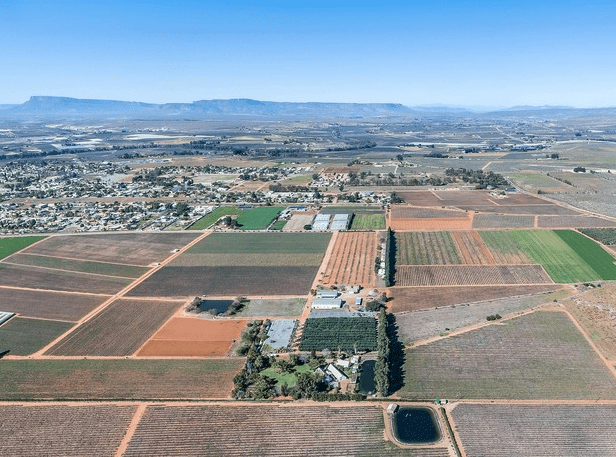
Vredendal is a town in the Matzikama Local Municipality on the West Coast of the Western Cape, South Africa. It lies in the lower Olifants River Valley, about 300 km north of Cape Town and 12 km inland from the coastal town of Lutzville. The town developed as a service and agricultural centre for the surrounding irrigation farms and is reached via the R363 and nearby R27 West Coast route. Vredendal serves the wider farming region, including Lutzville and Koekenaap, Ebenhaeserand the coastal settlements along the Olifants River mouth.
History of Vredendal
Origin of the name
The name means “valley of Peace” The settlement was established on a farm of the same name, which dates back to 1748. It was laid out as a suburb in 1933 at the start of the Olifants River irrigation project, and it gained town status only in 1944. It is the largest town in the region, known for agriculture, mining and viticulture. This includes raisins and table grapes, olives, potatoes, tomatoes, onions, pumpkins, watermelons and sweet melons: all made possible by the development of the water-transporting Olifants River Irrigation Scheme. Vredendal became a separate municipality in 1963.
The climate is subtropical desert, with mild winters (but it can get cold at night) and very hot summers. The sun shines all year round. The town is surrounded by the majestic Gifberg, Maskam and Koebee peaks. These create the hot and dry conditions in summer that make this ideal wine-producing countryside.
The postcode for Vredendal is 8160, and the license plate prefix is CV
Things to see and do in Vredendal
- Parkrun – Parc de Lausanne, Lausanne Rd,7.00 am every Saturday vredendal@parkrun.com
- The Matzikama Eco-Park, Matzikama means “place of water has hiking trails, bird hides, botanical gardens, and a bird aviary.
- The Olifants River wine route
- It is home to one of the largest wine cellars in South Africa. Namaqua Wines, as well as several boutique wineries
- Some of the most diverse examples of succulent plant species in the world can be seen in Vredendal.
- The annual ‘Rittelfees’ at the end of October brings together eight towns from the district for a music, arts and crafts festival.
Resources
Practical information for the Western Cape, Regulations, permits and helpful tips. See the Colourdots coastal and nature use guide
local WEATHER TODAY
Browse businesses and things to see in Vredendal

Useful Numbers
Residents and visitors can find important local contact numbers below, including police, medical services, utilities, and community facilities
-
Emergency Services
- Police: 027 201 3200
- Fire: 027 213 1379
- Ambulance: 10177
-
Medical
- Closest hospital: 027 312 2036
- Pharmacy; 027 213 1510
-
Municipal & Utilities
- Water; 027 201 3404:
- Electricity: 0823237464
-
Transport & Roads
- Traffic department: 027 213 1269
-
Community & Safety
- NSRI 087 094 9774
- SPCA: Matzikama dierebeskerming 027 213 4182
-
Local Contacts and Community Resources in Vredendal
- Tourism; 027 201 3376
- Home Affairs: 027 213 2052
- Post office; 027 213 1100
- Library: 027 213 1045
-
Schools inVredendal
- Spruitdrift 027 213 4344
Other towns in the Matzikama district include Bitterfontein; Doringbaai; Ebenhaeser; Klawer; Lutzville and Koekenaap; Strandfontein; and Van Rhynsdorp
- Colourdots is an independent regional information resource for the Western Cape.
Learn more about the project HERE