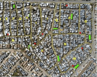
History of Wallacedene
- Province: Western Cape
- Coordinates: 33°51′30″S “18°44′0″E
- Area: 0.60 km2
- Municipality; City of Cape Town
This township was established as a result of the rapid urbanization and migration of people from rural areas to the city, seeking better opportunities. It has grown significantly over the years, and its development reflects the broader challenges and changes faced by many South African urban areas.
Historical Background
The township was established in the early 1990s during a period of significant social and economic change in South Africa. As more people moved to Cape Town in search of work and a better life, the city experienced a housing crisis, leading to the formation of informal settlements like Wallacedene. The township’s name is believed to be derived from an early landowner or figure in the area.
The postcode for Wallacedene is 7570
WEATHER IN WALLACEDENE TODAY
see all listings in wallacedene
Useful Numbers
- Police: Kraaifontein 021 980 5500
- Traffic department:
- Fire: Brackenfell Fire Station 021 417 0151
- Water: 021 546 3452
- Electricity: 0860 103 089
- Ambulance: 1077
- Post office; Kraaifontein 021 988 7482
- Closest hospital; Clinic 021 444 8601
- Library: Kraaifontein library 021 444 1066
- Schools: Wallacedene primary 021 986 0001


